 Magazine Posts
 Table of Contents
 Post title...
 Post title...
Post title...
Posted
|
Views: 1,232
The geology behind this area is even more diverse, as the boundaries of the park envelop the Highland Boundary Fault – one of the four faults upon which Scotland was pieced together. This fault is significant as it geologically separates the Highlands from the Lowlands but distinct changes can also be seen in the weather, vegetation, wildlife and landuse. The boundary fault cuts rights through the centre of Loch Lomond and the Trossachs, making them places of geological wonder and breathtaking views of landscapes so different from one another.
The Highland Boundary Fault marks the major change from hard Dalradian
metamorphic rock in the Highlands and softer Devonian sandstones in the
Lowlands. These two disparate crustal blocks were brought together between 450
and 420 million years
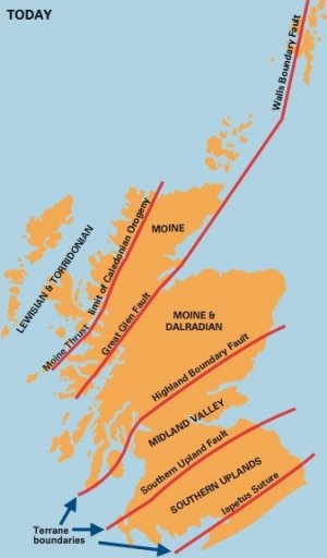
ago. The area above the fault is known as the Moine and
Dalradian terrane, and below the fault is the Midland Valley.
The hard Dalradian rocks were originally marine sands, muds, lime-rich
deposits and volcanic ash that were buried and altered by heat and pressure
during the Caledonian orogeny to become metamorphosed. New minerals were
formed: the sands and muds became slates, phyllites and schists. The softer
Midland Valley rocks were deposited in layers in ancient freshwater lakes,
which became compressed and hardened into red sandstones, pebbles and
conglomerates. Situated between these two terranes is the Highland Border
Complex, which contains rocks different than both the Highlands and Lowlands.
The Complex contains a sequence of lavas, conglomerates, limestones black
mudstones and sandstones that originated from the floor of an old ocean basin.
The actual Highland Boundary Fault line is marked by an intrusion of serpentine,
a base-rich mineral derived from great depths in the Earths crust.
Loch Lomond is the result of the erosive power of glaciers, which
scoured the Loch into the face of the Earth. The current location of the Loch
was the main corridor for ice movement originating from the north. Loch Lomond
is tadpole shaped; the north is narrow and deep where the glacier eroded more and
the south is wide and shallow where till and sediments were deposited (below).
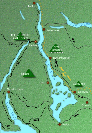
The most interesting result that this geology has had on the landscape
is the sharp change from Highlands to Lowlands, which can be seen from the
summit of many hills in the national park and also in Loch Lomond. The stretch of islands from Conic Hill, Inchmurrin,
Creinch and Inchcailloch are all part of the Highland Boundary Fault and make a
distinct line through the Loch. The national park offers many hillwalks but the most popular is Conic Hill as it provides the best vantage point of this geological phenomena. A popular scenic tourist trail, the West